

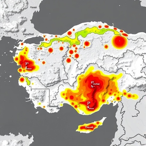
Asbestos, a naturally occurring mineral once lauded for its fire-resistant properties, has long been recognized as a silent threat to human health. When asbestos fibers become airborne and inhaled, they can lead to severe respiratory conditions, including asbestosis, lung cancer, and mesothelioma. The environmental implications of asbestos are equally dire, considering its persistence and mobility in soil and water systems. Karabulut and Yeşilnacar’s study meticulously maps these dangers by employing cutting-edge spatial analytical techniques that integrate field data with multispectral satellite imagery, enabling precise delineation of asbestos-contaminated zones across diverse terrains.
The researchers adopted a multi-tiered methodological framework aimed at isolating areas with elevated asbestos presence. Initially, high-resolution satellite images were processed to detect distinct spectral signatures indicative of asbestos-bearing mineral assemblages. These remote sensing datasets were then fused with GIS layers that encompassed topographical attributes, land use maps, and known geological formations predisposed to harbor asbestos minerals. The fusion of diverse spatial data allowed the team to create robust contamination risk models that visualize hotspots where human and ecological exposure is maximized.
One of the most compelling aspects of this research is its ability to transcend the limitations of traditional asbestos investigations, which often rely on sporadic ground sampling. The integration of remote sensing affords vast spatial coverage and the ability to monitor inaccessible or hazardous areas, turning what was once a painstakingly slow process into a dynamic, scalable surveillance technique. This advancement marks a paradigm shift in environmental risk assessment, underscoring the strategic value of technological innovation in confronting legacy pollutants.